


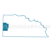
WOOLEYS STORE Voting District, Union County, Arkansas
About
Outline

Summary
| Unique Area Identifier | 528299 |
| Name | WOOLEYS STORE Voting District |
| County | Union County |
| State | Arkansas |
| Area (square miles) | 52.20 |
| Land Area (square miles) | 52.19 |
| Water Area (square miles) | 0.01 |
| % of Land Area | 99.98 |
| % of Water Area | 0.02 |
| Latitude of the Internal Point | 33.17388120 |
| Longtitude of the Internal Point | -92.92667950 |
Maps


Graphs
Select a template below for downloading or customizing gragh for WOOLEYS STORE Voting District, Union County, Arkansas


Neighbors
Neighoring Voting District (by Name) Neighboring Voting District on the Map
- Emerson TWP Voting District, Columbia County, AR
- LISBON Voting District, Union County, AR
- Magnolia East Voting District, Columbia County, AR
- MT HOLLY Voting District, Union County, AR
- NEW HOPE Voting District, Union County, AR
- THREE CREEKS Voting District, Union County, AR
Top 10 Neighboring County Subdivision (by Population) Neighboring County Subdivision on the Map
- Emerson township, Columbia County, AR (1,891)
- Village township, Columbia County, AR (699)
- Van Buren township, Union County, AR (659)
- Cornie township, Union County, AR (488)
- Boone township, Union County, AR (381)
- Garner township, Union County, AR (348)
- Tubal township, Union County, AR (282)
Top 10 Neighboring Unified School District (by Population) Neighboring Unified School District on the Map
- Magnolia School District, AR (17,186)
- Smackover School District, AR (4,267)
- Emerson-Taylor School District, AR (3,429)
- Junction City School District, AR (3,128)
Top 10 Neighboring State Legislative District Lower Chamber (by Population) Neighboring State Legislative District Lower Chamber on the Map
- State House District 7, AR (26,507)
- State House District 6, AR (25,251)
- State House District 4, AR (25,193)